Posts

N London urban walk: Finsbury Park to the river

Image
Total route: 9km/5.5 miles Possible early drop outs at 4 and 7.5km and elsewhere Easy walking on hardstanding throughout, mostly level No public toilets except at Farringdon station and Paternoster Square (near St Paul's) but there are many cafes and pubs en route     This route in some of the most built up parts of north London nevertheless takes you through many parks and gardens with surprisingly few roads to cross.         Starting on the south east side of Finsbury Park station, on Station Place, you will see across Seven Sisters Road the tiny entrance to Gillespie Park (red arrow), up a short flight of steps.          Take this and walk along the gravel path beside the railway.  This park was established as a local nature reserve by Islington council, and is a stronghold for biodiversity in the area. Continue always keeping to the right nearest the railway, following a tarmaced path down the hill past the Ecology Centre, then turn right onto Drayton park, past the Ars
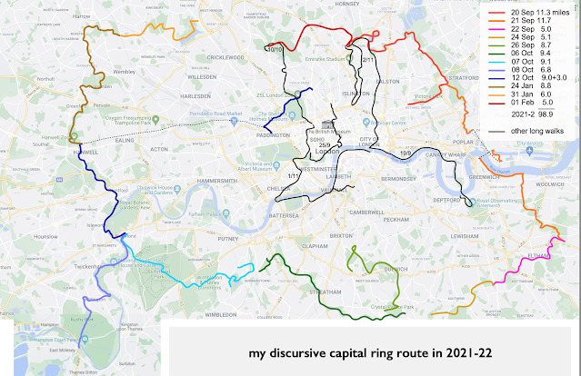
my discursive capital ring

Image
            Recently I had a second go at walking the Capital Ring , a long distance footpath that follows a route all around London for about 70 miles.  When I first did this a few years earlier, it took me to many beautiful stretches of countryside that exist within the Greater London boundary - ancient woods, wide heathland, and hidden pathways...          But anyone who knows the Capital Ring will know that it includes some particulalry boring stretches, such as the slightly whiffy stretch along the Outfall Sewer in east London, and the suburban maze behind Brent Cross.          So I decided to revisit the route and where necessary find more interesting diversions.  The result is shown above.  Now I'm once again revisiting parts of this journey and writing up in detail some of the sections I have enjoyed the most.  NOTE: In the posts  ‡ indicates a publicly available toilet that was open when I did the walk, though I cannot guarantee it will still be open in the future!   

SW london commons and woods

Image
Length: about 10.5 miles Grade: mostly easy, some small hills South west London has a wide range of open spaces and familiar routes such as the Capital Ring and the Thames Path, but this walk finds some less trodden paths through woods, heaths and commons. From New Malden station's ‡ north exit, continue north to the parish church, and turn into Cambridge Avenue, named after a royal duke who owned this land in the 19 th century. There is a sign confidently marking out the Beverly Brook Walk , a trail that follows this clear stream rising in Worcester Park and continuing to the Thames at Putney. At the end of the avenue you continue through what was once woodland but is now hollowed out as a golf course. Now you will catch a glimpse of the brook as you cross it, but this is the last you will see of it until Wimbledon Common, as the first section of the Walk that follows it is completely overgrown. Ahead you will hear the busy A3, where you will find an underpass. On the far s